Article Published on this web site on October 14th 2008                                                                                                                      Back to Main Page

Invited Article

Remote Sensing for Mapping Applications

Dr. K. V. Suryabhagavan
Assistant Professor in
Remote Sensing and GIS
Department of Earthsciences,
Faculty of Science,
Addis Ababa University
Remote sensing is the observation of an object from a distance. Examples are Aerial Photography and the use of satellites to observe the earth. Remote sensing Systems offer four basic components to measure and record data about an area of distance. These components include the energy source, the transmission path, the target and the satellite sensor. The digital data acquired by the satellites is transmitted to ground stations and can be used to reconstitute an image of the Earth’s surface. At Present Ikonas, Quickbird, Tes, Cartosat are high resolution satellites. Remotely sensed data acquired by the above earth observation satellites provides a number of benefits for studying the Earth’s surface, including.
  • continuous acquition of data  
  • regular revisit capabilities (resulting in up-to-date information) 
  • broad regional coverage 
  • good spectral resolution (including infra-red bands) 
  • good spatial resolution  
  • ability to combine satellite digital data with other digital data  
  • cost effective data  
  • map-accurate data  
  • possibility of stereo viewing  
  • large archive of historical data
Data is provided to the users as hard copy photographic data products, or as digital data products which can be viewed and manipulated on a variety of software systems. Satellite data is used to provide timely and detailed information about the Earth’s surface, especially in relation to the management of our renewable and non-renewable resources.

Some examples of uses of satellite data are:
  • assessment and monitoring of vegetation types and their status 
  • soil surveys
  • mineral exploration
  • map making and revision  
  • production of thematic maps
  • water resources planning and monitoring
  • urban planning
  • agricultural property management planning  
  • crop yield assessment
  • natural disaster assessment.


Mapping with IKONOS in relation to aerial orthoimage

IKONOS pan -1m pixel
(Source: US Geological Survey
 
Orthoimage 0.3m pixel (Source: US Geological Survey)

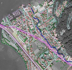
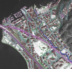
The next generation satellites would provide high resolution data. That high resolution images coupled with digital photogrametry for ortho-rectification and GIS contribute to generate large scale maps at good accuracy. The same can be used in upgrading existing maps
.

References

Remote Sensing and Image Interpretation by Lillisand, T.M. and Kiefer T.W., Jhon Wiley. 1999.

National Remote sensing agency, India

US Geological Survey