|
..

|
..

.
|
..
Tarun K.Raghuvanshi Ph.D
Project Consultant,
Department of Hydro & Renewable Energy,
Indian Institute of Technology, Roorkee
Professor (Adjunct), Graphic Era Hill University
Consulting Engineering Geologist
Associate Professor
(Retd.), Department of Earth Sciences,
Addis Ababa University, Ethiopia
|
|
1.
|
Kassaw, M.T., Feyisa, B.R., Raghuvanshi,
T.K. et al. (2025) Numerical analysis for failure and
deformation assessment of the waterway tunnel, Wabe Hydropower Project, Central
Ethiopia. Arab J Geosci 18, 30 (2025). https://doi.org/10.1007/s12517-024-12166-1
|
2.
|
Ali, Y., Gugsa, T.H., Raghuvanshi,
T.K. (2024). GIS-based statistical analysis
for landslide susceptibility evaluation and zonation mapping: A case from
Blue Nile Gorge, Gohatsion-Dejen road corridor, Central Ethiopia. Environmental
Challenges. 16: 100968 (Elsevier) (Impact SJR: 0.99) (https://doi.org/10.1016/j.envc.2024.100968)
|
3.
|
Gebreegziabher,
T, Suryabhagavan, K.V., Raghuvanshi, T.K (2023)
WebGIS-based decision support system for soil erosion assessment in Legedadi
watershed, Oromia Region, Ethiopia. Geology, Ecology, and Landscapes, 7(1):97
- 114 DOI: 10.1080/24749508.2021.1924441 (Taylor & Francis) (Impact Factor:
0.35) (Published online: 07 May 2021). https://www.tandfonline.com/doi/full/10.1080/24749508.2021.1924441
|
..
4..
|
Gudissa, L., Raghuvanshi, T.K,
Meten, M., Chemeda, Y.C., Schmerold, R. (2023)
Characterization of Mesozoic Limestone Aggregate for Pavement Material
in Harar-Dere Dawa, Eastern Ethiopia. /Journal of Jilin University (Engineering
and Technology Edition) 42:687 - 713 https://osf.io/a86be/
|
Book authored/prepared
Raghuvanshi, T.K. & Geremew,
Z (2019) Laboratory manual for Engineering Geology laboratory testing, Publisher
Ethiopian Academy of Science (EAS), Addis Ababa Ethiopia.
|
|
|
5.
|
Mekonnen, A.A., Raghuvanshi, T.K.,
Suryabhagavan, K.V., Kassawmar, T. (2022). GIS-based landslide susceptibility
zonation and risk assessment in complex landscape: A case of Beshilo watershed,
northern Ethiopia. Environmental Challenges Available online – 20th July
2022 (Elsevier) (Impact Factor: 3.819) https://www.sciencedirect.com/science/article/pii/S2667010022001421
.
|
6.
|
Gudissa, L., Raghuvanshi, T.K,
Meten, M., Chemeda, Y.C. (2022). A GIS – AHP based approach for optimization
of quarry site location around harer and Dire – Dawa Towns, Eastern Ethiopia.
Journal of Environmental Engineering and Landscape Management, 30 (1): 151
– 164 ((Vilnus Gediminas Technical University) (Impact factor : 1.628) DOI:
https://doi.org/10.3846/jeelm.2022.16280
https://journals.vilniustech.lt/index.php/JEELM/article/view/16280
.
|
7.
|
Shano, L, Raghuvanshi, T.K.,
Meten, M. (2022) Fuzzy
set theory and pixel-based landslide risk assessment: the case of Shafe and
Baso catchments, Gamo highland, Ethiopia. Earth Sci Inform (2022). https://doi.org/10.1007/s12145-022-00774-y.
Published on line; March 11th 2022 https://link.springer.com/article/10.1007/s12145-022-00774-y
.
|
8.
|
Shano, L, Raghuvanshi, T.K.,
Meten, M. (2021) Landslide
Hazard Zonation using Logistic Regression Model: The Case of Shafe and Baso
Catchments, Gamo Highland, Southern Ethiopia. Geotech Geol Eng (Published
online: 13 June 2021) (Springer) (Impact Factor: 1.658)
https://doi.org/10.1007/s10706-021-01873-1
,,
|
9.
|
Shano, L, Raghuvanshi, T.K.,
Meten, M. (2021) Landslide
susceptibility mapping using frequency ratio model: In the case of Gamo
highland, South Ethiopia, Arabian Journal of Geosciences 14: 623 (Springer)
(Impact Factor: 1.327). https://doi.org/10.1007/s12517-021-06995-7
.
|
10.
|
Gudissa, L., Raghuvanshi, T.K.,
Meten, M., Chemeda, Y.C. (2021)
TES Analysis for
Crushed Stone Aggregate Quarry Site Selection: The case of Limestone Terrain
around Harer-Dire Dawa towns, Eastern Ethiopia. Arabian Journal of Geosciences
14: 1-21 (Springer) https://doi.org/10.1007/s12517-021-06614-5
.
|
11.
|
Gerbo. A, Suryabhagavan, K.V.,
Raghuvanshi, T.K (2020)
GIS-based approach
for modeling grid-connected solar power potential sites: a case study of
East Shewa Zone, Ethiopia, Geology, Ecology and landscapes, (Taylor
& Francis)m Published online on Aug. 24’ 2020 https://doi.org/10.1080/24749508.2020.1809059
(Impact Factor: 0.35)
.
|
12.
|
Shano, L, Raghuvanshi, T.K.,
Meten, M. (2020). Landslide susceptibility evaluation
and hazard zonation techniques – a review, Geoenvironmental Disasters.7:
1-18 (Springer). https://doi.org/10.1186/s40677-020-00152-0
(Impact Factor: 0.584)
.
|
13.
|
Raghuvanshi, T.K, Suryabagawan,
K.V and Hailemariam, T (2020) Ultra low head hydro power resource
assessment and management – A solution for rural electrification. In:
Resource Management for inclusive Development international Conference
organized in association with Maharashtra Bhugolshastra Parishad Pune,
Sponsored by savitribai Phule, Pune University, Pune, 14 -15 February, 2020.
.
|
14.
|
Suryabagawan, K.V, Raghuvanshi,
T.K, and Gummidi Sridhar (2020) Remote sensing role to understand
climate change in semi arid regionsEthiopia. In: Resource Management for
inclusive Development international Conference organized in association
with Maharashtra Bhugolshastra Parishad Pune, Sponsored by savitribai
Phule, Pune University, Pune, 14 -15 February, 2020.
.
|
15.
|
Geremew Lamessa, Tilahun Mammo,
Raghuvanshi T.K.,(2019). Homogenized Earthquake Catalog and
b-value mapping for Ethiopia and its adjoining regions, Geoenvironmental
Disasters.6: 1-24 (Springer) (Impact Factor: 0.584).
https://link.springer.com/article/10.1186/s40677-019-0131-y
..
|
16.
|
Demessie, S and Raghuvanshi, T.K. (2019). Landslide Hazard Evaluation and
Zonation in Dilbe Town and its surrounding areas, North-western Central
Ethiopia – A GIS based Grid Overlay Statistical Approach, J. of Geomatics,
13(1), 79 – 92. https://isgindia.org/volume-13-no-1-april-2019/
.
|
17.
|
Raghuvanshi, T.K, (2019). Governing factors influence
on rock slope stability – Statistical analysis for plane mode of failure
J. King Saud Uni. Sci., 31 (4): 1254 - 1263 (Elsevier)
(Impact Factor: 2.835), Published online January 7’ 2019
https://doi.org/10.1016/j.jksus.2019.01.002
https://www.sciencedirect.com/science/article/pii/S1018364718314320
..
|
18.
|
Mengistu. F., Suryabhagavan K.V.,
Raghuvanshi,
T.K., Lewi,
E., (2019). Landslide Hazard Zonation and
Slope Instability Assessment using Optical and InSAR Data: A Case Study
from Gidole Town and its Surrounding Areas, Southern Ethiopia,
Remote Sensing of Land, 3(1), 1-14.
http://www.gathacognition.com/journal/gcj1/remote-sensing-of-land
..
|
19.
|
Raghuvanshi, T.K , (2019). Plane failure in Rock slopes – A review
on stability analysis techniques, J. King Saud Uni. Sci.,
31 (1): 101-109. (Elsevier) (Impact Factor: 2.835).
(Published online June 17’ 2017) https://doi.org/10.1016/j.jksus.2017.06.004
http://www.sciencedirect.com/science/article/pii/S1018364717304470
..
Article among "Most Downloaded Articles List" since June 2017
https://www.journals.elsevier.com/journal-of-king-saud-university-science/most-downloaded-articles
..
|
20.
|
Chimidi, G, Raghuvanshi, T.K
, Suryabhagavan, K.V., (2017). Landslide hazard evaluation and zonation
in and around Gimbi town, western Ethiopia – a GIS-based statistical
approach. Applied Geomat, 9(4): 219-236 (Springer) DOI
10.1007/s12518-017-0195-x.
https://link.springer.com/article/10.1007%2Fs12518-017-0195-x
..
|
21.
|
Berhanu, M, Raghuvanshi, T.K.,
Suryabhagavan, K.V., (2017). Web- Based GIS Approach
for Tourism Development in Addis Ababa City, Ethiopia. Malaysian
J. Remote Sensing & GIS, 6 (1): 13 – 25 http://www.igrsm.com/mjrsgis/issues.html
.
|
22.
|
Ermias, B, Raghuvanshi, T.K,
Abebe, B., (2017). Landslide Hazard Zonation (LHZ) around
Alemketema Town, North Showa Zone, Central Ethiopia - A GIS based expert
evaluation approach, Int. Jr. Earth Sci. & Engg., 10
(1): 33-44 http://cafetinnova.org/innova/journalView/IJEE.htm#issuePublishedList
.
|
23.
|
Hamza T, Raghuvanshi. T.K., (2017). GIS based Landslide Hazard Evaluation
and Zonation - A case from Jeldu District,Central Ethiopia, Journal
of King Saud University – Science, J. King Saud Uni. Sci.,,
29(2):151-165. (Elsevier) (Impact Factor: 2.835)
(Published on line May 28th 2016) http://www.sciencedirect.com/science/article/pii/S1018364715301129
.
|
24.
|
Raghuvanshi T.K, Negassa, L. and Kala.P.M.
(2015). GIS based Grid Overlay Method versus
Modeling Approach – A Comparative Study for Landslide Hazard Zonation
(LHZ) in Meta Robi District of West Showa Zone in Ethiopia. Egypt.
J. Remote sensing Space Sci., 18 (2): 235-250. (Impact Factor: 1.79)
(Elsevier) http://www.sciencedirect.com/science/article/pii/S1110982315000356
.
|
25.
|
Midekssa, K, Raghuvanshi T.K., Abebe, B. (2015). Investigating causes of origin and
engineering geological characterization of ground cracks around Ziway
and Ropi area in central rift valley of Ethiopia, Int. Jr. Earth
Sci. & Engg. 8(3): 1068-1079.
http://cafetinnova.org/innova/journalView/IJEE.htm#issuePublishedList
.
|
26.
|
Girma, F, Raghuvanshi, T.K, Ayenew T. and Hailemariam,
T. (2015). Landslide hazard zonation in
Ada Berga District, Central Ethiopia – A GIS based statistical approach.
J. of Geomatics, 9 (i): 25 -38 https://isgindia.org/volume-9-no-1-april-2015/
..
|
27.
|
.Regessa,
B, Raghuvanshi,
T.K. and Seifu,
K. (2015). Quarry site selection and geotechnical
characterization of ballast aggregate for Ambo-Ijaji railway project
in Central Ethiopia: An integrated GIS and Geotechnical Approach.
Engg. Geol. For Society and Territory, Vol. 6, Springer, Switzerland,
pp 329-335 (DOI: 10.1007/978 -3-319-09060-3_56), http://link.springer.com/chapter/10.1007/978-3-319-09060-3_56?no-access=true
(Springer)
.
|
28.
|
Woldegeorgis, H, Raghuvanshi
T.K., Atnafu, B.(2014).Landslide hazard zonation using
expert evaluation technique: a case study of the area between Gohatsion
town and the Abay (Blue Nile) River, Central Ethiopia, SINET:
Ethiopian J. Sci.. 37(2): 75-94.
https://www.ajol.info/index.php/sinet/article/view/127863
.
|
29.
|
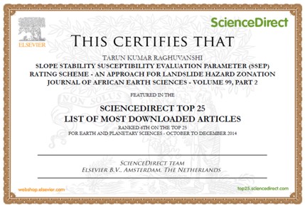
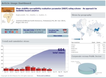
Raghuvanshi, T.K, Ibrahim, J and Ayalew, D. (2014). Slope stability susceptibility
evaluation parameter (SSEP) rating scheme – An approach for landslide
hazard zonation. J.Afr. Earth Sci, 99: 595-612 (Elsevier)
(Impact Factor: 1.855) http://dx.doi.org/10.1016/j.jafrearsci.2014.05.004
..
|
|
|
|
|
Article
in Top 25 Hottest Article list at No.6 of Earth and
Planetary Sciences for October to December 2014, list released by
Science Direct
|
|
30.
|
Raghuvanshi, T.K, Kala, P.M and Singh, M, (2014). Landslide Disaster Management
and Reduction- An approach through Remote Sensing and GIS” In: Landscape
Ecology and Water Management, Proceedings of International Geographical
Union (IGU) Rohtak Conference, Vol-2, Advances in Geographical and
Environmental Sciences, (Singh, M, Singh, R.B, Hassan, M.I. eds.),
Springer Japan, pp 33-40. (DOI: 10.1007/978-4-431-54871-3_2), (Springer)
https://doi.org/10.1007/978-4-431-54871-3_3
.
|
31.
|
Seid, J.I.,
Raghuvanshi, T.K. and Ayalew, D. (2014) Landslide hazard zonation
mapping of Mersa (Northern Ethiopia) using slope stability susceptibility
evaluation parameter (SSEP) rating scheme. 3rd International Conference
on Hydrology & Meteorology. Hydrology: Current Research. September 15-16,
2014, Hyderabad International Convention Centre, India (ISSN: 2157-7587)
..
|
32.
|
Ayele, S, Raghuvanshi, T.K. and Kala, P.M, (2014). Application of Remote Sensing and
GIS for Landslide Disaster Management - A case from Abay Gorge,
Gohatsion – Dejen Section, Ethiopia. In: Landscape Ecology and Water
Management, Proceedings of International Geographical Union (IGU)
Rohtak Conference, Vol-2, Advances in Geographical and Environmental
Sciences, (Singh, M, Singh, R.B, Hassan, M.I. eds.), Springer Japan,
pp 15-32 (DOI: 10.1007/978-4-431-54871-3_2), (Springer) https://doi.org/10.1007/978-4-431-54871-3_2
.
|
33.
|
Raghuvanshi, T.K, Ibrahim, J. and Ayalew,
D. (2013) Slope stability susceptibility evaluation parameter (SSEP) rating
scheme – An approach for landslide hazard zonation 24th Colloquium of African
Geology (CAG24) “40 years of GSAf (1973-2013): Earth Sciences Solutions
to African Development Challenges” – An international Conference, January
8-14, 2013, Addis Ababa, Ethiopia
|
34.
|
Mulatu E, Raghuvanshi, T.K & Bekele Abebe (2010). Assessment
of slope stability and remedial measures around Gilgel Gibe-II Hydroelectric
Project, Southwest Ethiopia. SINET: Ethiopian J. Sci.,
33(1): 1-20. http://www.ajol.info/index.php/sinet/article/view/70560/59165
.
|
35.
|
Mulatu,E, Raghuvanshi, T.K & Abebe. B. (2009). Landslide
Hazard Zonation around Gilgel Gibe-II Hydroelectric Project, Southwestern
Ethiopia. SINET: Ethiopian J. Sci, 32 (1):.9-20.
http://www.ajol.info/index.php/sinet/article/view/68733/56805.
..
|
36.
|
Mulatu, E., Raghuvanshi, T.K., Abebe,
B. (2009). The studies of slope stability around Gilgel Gibe-II Hydroelectric
project, Southwest of Ethiopia. Proc. First World Congress for Young Earth
scientist for Community, Beijing, China 25-28 October
|
37.
|
Raghuvanshi, T.K, Solomon, N., Gazahgen,
A. Woldegiorgis, H.(2008). Small Hydro Power – A Solution for Rural
Electrification in Ethiopia In: Proceeding of 6th Congress, Earthsciences
for Society in the context of the UN proclaimed International year of the
Planet Earth 2008, (Alemu, T ed.) The Ethiopian Geoscience and Mineral Engineering
Association, November 8th 2008, Everest Printers, Addis Ababa, Ethiopia
|
38.
|
Raghuvanshi, T.K, Solomon, N, Gazahgen, A, Woldegiorgis,
H. (2008). Small Hydro Power – A Solution for Rural Electrification
in Ethiopia. In: Proceeding of 6th Congress, Earthsciences
for Society in the context of the UN proclaimed International year
of the Planet Earth 2008, (Alemu, T ed.) The Ethiopian Geoscience
and Mineral Engineering Association, November 8th 2008, Everest Printers,
Addis Ababa, Ethiopia..
..
|
39.
|
Raghuvanshi, T.K, Belwal. R & Solomon, N.
(2006). An approach to develop Tourism Potential in Ethiopia through
Geographical Information System. Consortium J. Hospitality and
Tourism, 11(1) : 35-42.
.
|
40.
|
Nehemia Solomon, Raghuvanshi, T.K. (2005). Assessment of
Small Hydropower Potential in Muger, Jemma and Waleka Sub-basins
of Abay Basin (Central Ethiopia). In: Proceedings 9th Symposium
on sustainable water resources development, Arba Minch, Ethiopia.
.
|
41.
|
Raghuvanshi, T.K & Nehemia Solomon.
(2005). A Sensitivity Analysis of a Natural slope having Planar
mode of failure. J. Ethiopian Asso. of Civil
Engg., 4, (1): 27-40.
.
|
42.
|
Kumar, A, Rees, G & Raghuvanshi, T. K. (2002). Small Hydropower Assessment
– A Solution through Hydra-HP Software, MapIndia2002, New Delhi
http://geospatialworld.net/Paper/Application/ArticleView.aspx?aid=1448
.
|
43.
|
Singh, S.P, Arun Kumar &
Raghuvanshi,
T.K. (2000).
Small Hydro Power Potential in Uttarakhand Region. Seminar
on Harnessing of Uttarakhand Resources for the Development
of The Himalayans, Dehradun
....
|
44.
|
Sharma, S & Raghuvanshi, T & Sahai, A. (1999).
An engineering geological appraisal of Lakhwar dam, Garhwal
Himalaya India.Engg. Geol, 53: 381-398 (Elsevier)
(Impact Factor: 4.42) https://doi.org/10.1016/S0013-7952(99)00038-1
.
|
45.
|
Anbalagan, R, Raghuvanshi,
T. and Sharma, S. (1996). Stability analysis of reservoir
slopes of Kishau Dam, Garhwal Himalaya, India. Workshop
on design practices in Earthquake Geotechnical Engineering,
Roorkee, pp.112-130.
....
|
46.
|
Anbalagan, R, Sharma, S &
Raghuvanshi, T. (1996). Stability
Evaluation of Lakhwar Underground Power House incorporation
insitu stresses. Workshop on design practices in Earthquake
Geotechnical Engineering, Roorkee.pp 191-200.
....
|
47.
|
Anbalagan, R, Sharma, S &
Raghuvanshi,
T. (1996).
An engineering geological appraisal of the Jamrani Dam site,
across the Gaula river in Kumaun Himalaya, India. Engg. Geol.,
42: 83-94 (Elsevier). (Impact Factor: 4.42) https://doi.org/10.1016/0013-7952(95)00059-3
.....
|
48.
|
Sharma, S & Raghuvanshi, T
& Anbalagan, R, (1995).Plane failure analysis of rock slopes.
Geot. & Geol. Engg, 13: 105 - 111. (Springer)
(Impact Factor: 1.75). https://link.springer.com/article/10.1007/BF00421876
.
|
49.
|
Anbalagan, R, Sharma, S &
Raghuvanshi,
T. (1994).Stability
analysis of Abutments of Jamrani Dam, Kumaun Himalaya,
India. International Symposium of Quaternary, Tehran, Iran.
.
|
50.
|
Raghuvanshi, C.S., Raghuvanshi, T.K.,
Kaur, M. (1993) Impact assessment of developmental activities on land, water
and forest resources in U.P. Hills, In: Hiimalaya: A regional perspective,
Resources, Environment and Development (ed. Rawat, M. S. S,), Daya Publishing
House, Delhi. PP. 130
...
|
51.
|
Anbalagan, R, Sharma, S &
Raghuvanshi, T. (1992).
Rock mass stability evaluation using modified SMR approach.
Sixth National Symposium on Rock Mechanics, pp 258 - 268.
.
|
..
|
..
|